
The tragic landslide from last Saturday, March 22, and its frustrating and grief-stricken aftermath has focused minds. The U.S. Geological Survey has provided a preliminary summary of the event, which resulted from rains and saturated soils on unstable slopes. The official death toll remains below 20, but some 90 more people are missing and unaccounted for. Some 30 houses were covered with debris; a mile of road was wiped out. Rains over the past week have hampered rescue (and now recovery) efforts, and raised fears of further risks to rescue workers (and residents) in the area.
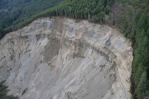 Landslide risk is widespread across the entire length of the Pacific coast. But landslides, their causes, and the hazards they pose come in more than one flavor. For example, most of the death toll resulting from the 1964 Alaska earthquake resulted from liquefaction and a massive underwater landslide in and around Port Valdez, which triggered a major tsunami. (The death toll from that event, which took 139 lives in the context of violent geophysical upheaval over thousands of square miles, may prove not that much greater from this smaller-scale rain-caused slide.)
Human decisions, particularly with regard to land use, account for much of today’s vulnerability. Some of that risk stems from a natural desire to enjoy the breathtaking vistas that hillside homes often enjoy. But some stems from poverty. Worldwide, urban slums don’t just fail to provide their occupants with adequate sanitation or protection from the elements on fair-weather days; because they’re often consigned to less-desirable real estate – dangerous, unstable slopes in particular – they become death traps when the earth starts to shake (as in Haiti), or the heavy rains come (as in Rio de Janeiro’s favelas). From PreventionWeb (one report of many):
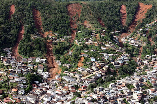 One of these neighbourhoods is Roupa Suja, the top of which is located right below a vertical wall of rock and considered a Zona de Risco – or risk area – by the Rio de Janeiro city government. Technically, residents are prohibited from building and living in this area; but many are so poor that they have no alternative place to build. The majority of the residents living in this area immigrated to Rio attempting to escape even greater poverty in the rural drought-stricken northeast. Others immigrated from different favelas in Rio after urban renewal campaigns razed their homes. Some also came from poorer favelas on the city’s periphery.
Several people die every year in mudslides caused by heavy rains in Rio’s favelas. Deforestation at the edge of Rochina, as it expands into the national forest of Tijuca, has worsened this risk. Rio’s municipal government, as well as residents themselves, have built aqueducts to channel the water away from homes; but these do not protect all areas of the favela. The danger of falling rocks is perhaps greater than that of rain. Since the homes at the top of the favela are directly beneath a vertical overhang, rocks break off due to erosion and fall on the homes below.
Faced each day with multiple types of risk – from natural hazards, violence and disease – the residents of Roupa Suja’s Zona de Risco lead a precarious and difficult life. Most stay because they have nowhere else to go.
Sometimes we create landslide risk as much as we simply choose to live in it. We often do this in our quest for natural resources. For example, on the evening of April 10, 2013, the Bingham Canyon strip mine experienced the largest non-volcanic landslide ever recorded in North America. Here’s the abstract from the linked article:
On the evening of 10 April 2013 (MDT) a massive landslide occurred at the Bingham Canyon copper mine near Salt Lake City, Utah, USA. The northeastern wall of the 970-m-deep pit collapsed in two distinct episodes that were each sudden, lasting ~90 seconds, but separated in time by ~1.5 hours. In total, ~65 million cubic meters of material was deposited, making the cumulative event likely the largest non-volcanic landslide to have occurred in North America in modern times. Fortunately, there were no fatalities or injuries. Because of extensive geotechnical surveillance, mine operators were aware of the instability and had previously evacuated the area. [emphasis added] The Bingham Canyon mine is located within a dense regional network of seismometers and infrasound sensors, making the 10 April landslide one of the best recorded in history. Seismograms show a complex mixture of short- and long-period energy that is visible throughout the network (6–400 km). Local magnitudes (ML) for the two slides, which are based on the amplitudes of short-period waves, were estimated at 2.5 and 2.4, while magnitudes based on the duration of seismic energy (md) were much larger (>3.5). This magnitude discrepancy, and in particular the relative enhancement of long-period energy, is characteristic of landslide seismic sources. Interestingly, in the six days following the landslide, 16 additional seismic events were detected and located in the mine area. Seismograms for these events have impulsive arrivals characteristic of tectonic earthquakes. Hence, it appears that in this case the common geological sequence of events was inverted: Instead of a large earthquake triggering landslides, it was a landslide that triggered several small earthquakes.
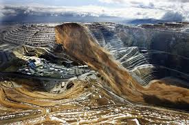 Normally, some 2000 workers might have been on this site. However, as emphasized, the event caused no casualties because geologists and mining engineers had been keenly aware of the risks, seen slippage starting, and had evacuated the operation 24 hours before the slumping occurred.
Did you happen to notice the qualifier describing this event? The largest non-volcanic landslide ever recorded? Greater risks are out there. Here’s one, also threatening the Pacific Northwest: mudslides (lahars) off the slopes of Mount Rainier:
Mount Rainier, an active volcano currently at rest between eruptions, is the highest peak in the Cascade Range. Its edifice, capped by snow and 25 glaciers, has been built up by untold eruptions over the past 500,000 years. It last erupted in 1894-95, when small summit explosions were reported by observers in Seattle and Tacoma. Mount Rainier’s next eruption might be of similar or larger size and could produce volcanic ash, lava flows, and avalanches of intensely hot rock and volcanic gases, called “pyroclastic flows.”
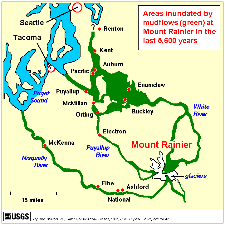
Some of these events swiftly melt snow and ice and could produce torrents of meltwater that pick up loose rock and become rapidly flowing slurries of mud and boulders known as “lahars.” In contrast to lava flows and pyroclastic flows that are unlikely to extend farther than 10 miles from the volcano’s summit and remain within Mount Rainier National Park, the largest lahars can travel for tens of miles and reach Puget Sound…
…At Mount Rainier, the risk from lahars is greater than from lava flows, volcanic ash fall, or other volcanic phenomena because some pathways for future lahars are densely populated and contain important infrastructure such as highways, bridges, ports, and pipelines. Lahars look and behave like flowing concrete, and they destroy or bury most manmade structures in their paths. Past lahars probably traveled 45 to 50 miles per hour and were as much as 100 feet or more thick where confined in valleys near the volcano. They thinned and spread out in the wide valleys downstream, slowing to 15 to 25 miles per hour. Deposits of past lahars are found in all of the valleys that start on Mount Rainier’s flanks…
…Mount Rainier has erupted less often and less explosively in recent millennia than its well-known neighbor, Mount St. Helens. However, the proximity of large population centers in valleys susceptible to lahars from Mount Rainier makes it a far greater threat to life and property than Mount St. Helens for the following reasons:
Population and development at risk: About 80,000 people and their homes are at risk in Mount Rainier’s lahar-hazard zones. Key infrastructure such as major highways and utilities cross through these zones, which also contain economically important businesses, hydroelectric dams, and major seaports…
…During the past several thousand years large lahars have reached the Puget Sound lowland on average at least once every 500 to 1,000 years. Smaller flows not extending as far as the lowland occurred more frequently. If future large lahars happen at rates similar to those of the past, there is roughly a 1-in-10 chance of a lahar reaching the Puget Sound lowland during an average human lifespan.
There may be little or no advance warning: Studies by U.S. Geological Survey (USGS) scientists show that at least one of Mount Rainier’s recent large landslide-generated lahars may have occurred when the volcano was quiet and not providing the warning signs typical of a restless and erupting volcano. In such a rare case, the only warning could be a report that a lahar is already underway…
…Mount Rainier can generate two types of lahars that can threaten surrounding valleys:
Meltwater-generated lahars: Mount Rainier supports more than one cubic mile of glacial ice-as much as all other Cascade Range volcanoes combined. During past eruptive episodes, swift melting of snow and ice by pyroclastic flows and other events caused numerous lahars. Such lahars would be preceded by events that warn of an impending eruption.
Landslide-generated lahars: Landslides can be triggered when molten rock (magma) intrudes into a volcano and destabilizes it, as happened at Mount St. Helens in 1980, or they may be triggered by large earthquakes. They may also be the result of the eventual failure of rocks that were weakened by the action of acidic fluids. Magma releases gases and heat creating hot, acidic ground water that, over time, can convert hard volcanic rock into weak, clay-rich rock by a process called hydrothermal alteration. When masses of water-saturated clay-rich rock slide away, they transform rapidly into a lahar. Although most large landslides at Mount Rainier occurred during eruptive periods and were probably triggered by magma intrusion or by explosive eruptions rocking the volcano, the origin of at least one, the 500-year-old Electron lahar, may not be related to eruptions. This lahar left deposits as much as 20 feet thick, and buried an old-growth forest in the vicinity of modern-day Orting.
 In summary, much landslide risk is self-inflicted: arising from land use preferences, or the quest for mineral resources, or imperfections in social justice. The question also arises: if it was possible to see the Bingham Canyon slide coming, and to evacuate the site, might it be possible to provide more warning systems for residential areas, say, for the highways and homes in the shadow of Mount Rainier and similar sites? Perhaps in times past the cost was prohibitive, but with advances in technology it needn’t remain so. If we’re in the business of building a weather-ready nation, surely the landslide risk should be factored in.
Excellent work, Bill!
Thanks for the insights Bill. We live directly in the green mudslide area near Mt. Rainier and the thought of a mudslide or volcanic event is scary. As part of the community Emergency Response Team our leaders say we should be prepared for the “when” not “if.” We must be ready and we need to factor in warning systems for these types of events.
Thanks for the on-the-ground perspective, Stephanie. Warmest regards…